
The United States borders the Pacific Rim of Fire, the most geologically active region on earth, and the past few months have provided us reminders of the dangers that exist. Starting on November 12th, Pavlov Volcano, the most active volcano in Alaska, began erupting, pushing lava out from a vent near its summit. The ash cloud from this eruption is likely to cause disruption for air travel, as the National Weather Service warned airplanes to avoid airspace near the area. Pavlov is located along the Aleutian Range, 625 miles southwest of Anchorage, and lies along a popular international air route connecting Europe, North America and Asia. The volcano has 40 recorded eruptions, which are known to last for weeks and even months.
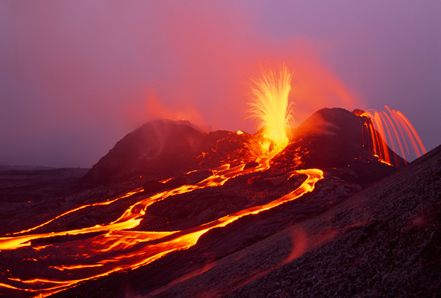
Meanwhile, residents of Pahoa, a small town of 1,000 people in Big Island of Hawaii, have had their own encounter with volcanic lava since June of this year. The Kilauea volcano, the most active on earth and located on Hawaii’s Big Island, has been erupting continuously for more than 31 years. One such lava flow from a June 2014 eruption has been advancing slowly and edging closer to the town. Although, the leading edge of the flow stalled about 170 yards above the Pahoe Village road by the end of October, the oozing stream of lava burned down the first structure in early November, an abandoned house and barn that is estimated to be worth $200,000. Officials are closely watching the flow as it poses a threat to a vital road, Highway 130, the lifeline to the Puna district of the Big Island.
These two incidents are stark reminders of how our world is constantly moving and churning around the 25,000 mile horseshoe shaped arc that is referred to as the Pacific Rim of Fire. This region has 452 volcanoes and is home to over 75% of the world’s active and dormant volcanoes. The Ring of Fire is a direct result of plate tectonics, the movement and collision of the various plates of the earth in this region. The eastern section of the ring is the result of the Nazca Plate and the Cocos Plate being subducted beneath the westward moving South American Plate. The Cocos Plate is being subducted beneath the Caribbean Plate, in Central America. A portion of the Pacific Plate is moving beneath the North American Plate. Along the northern portion, the northwestward-moving Pacific plate is being subducted beneath the Aleutian Islands arc. Farther west, the Pacific plate is being subducted along the Kamchatka Peninsula arcs on south past Japan. The southern portion is more complex, with a number of smaller tectonic plates in collision with the Pacific plate.
The 1980 eruption of Mount St. Helens in Washington State was the most significant volcanic incident to occur in the contiguous 48 U.S. states in recorded history, exceeding the destructive power and volume of material released by the 1915 eruption of California’s Lassen Peak. The eruption was preceded by a two-month series of earthquakes and steam-venting episodes caused by an injection of magma at shallow depth below the mountain, creating a huge bulge and a fracture system on Mount St. Helens’ north slope. An earthquake at 8:32 a.m. on May 18, 1980 caused the entire weakened north face to slide away, suddenly exposing the partly molten, gas- and steam-rich rock in the volcano to lower pressure. The rock responded by exploding into a very hot mix of pulverized lava and older rock that sped toward Spirit Lake so fast that it quickly passed the avalanching north face.

About 90% of the world’s earthquakes and 80% of the world’s largest earthquakes occur along this arc. This region has also registered all of the catastrophic magnitude 9.0 or larger earthquakes recorded on earth, including the largest recorded earthquake of magnitude 9.5 in southern Chile in 1960.
Major earthquakes along this belt have also caused massive tsunamis. The 2011 magnitude 9.0 in Japan unleashed a destructive tsunami that wreaked havoc, including causing the meltdown of a nuclear reactor in Fukushima. Almost 10 hours after the quake, the tsunami reached the Northern California coast and caused extensive damage at the Santa Cruz harbor.
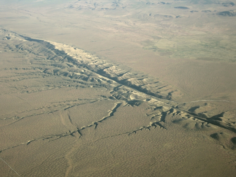
The Pacific Rim of Fire also includes the famous and active San Andreas Fault zone of California, a transform fault which offsets a portion of the East Pacific Rise under southwestern United States and Mexico. This fault lies below some of the most populated metro areas in the US, including San Diego, Los Angeles and San Francisco. The northern segment of the fault runs through the Santa Cruz Mountains, epicenter of the 1989 Loma Prieta earthquake, then on up the San Francisco Peninsula. The fault runs offshore at Daly City south of San Francisco, and is the approximate location of the epicenter of the 1906 San Francisco earthquake.
For millions of inhabitants of the Pacific coast of North, Central and South America, Japan, Philippines, Indonesia, New Zealand, and other islands nations, home is a rather dangerous cauldron, with a possibility of volcanoes, earthquakes or tsunamis. However, so far, the human endurance and resilience has conquered these adversaries as we continue to thrive in the Pacific Rim of Fire.
